
RE-BALLS COMPETITION
Washington, DC’s Potomac River - roughly 405 miles long - has been radically altered by water control projects. These lateral changes can be seen when looking back through historic maps. However, the much more frequent vertical tidal fluctuations are rarely seen. If these daily tidal ebbs and flows can be seen as clearly as looking through historic maps- Washingtonian’s would be more alert about sea level rise and how it threatens the city’s future.
Like the proposed gallery space, this proposition takes you beneath the surface to explore an active yet relatively invisible process within the district. Slack tide is an art installation structured by tidal data from the Potomac. This installation explores the value and potential of making invisible data flows into tangible material. A year of tidal metrics was collected from a USGS hydrologic unit located at Latitude 38°54'12.1", Longitude 77°04'03.6" at elevation 0.00. The high and low tidal data was organized then structured and normalized through an algorithm that plotted the data in three dimensional space. The average high tide and low tide of each day is represented by a ball. The high tide balls are suspended above and the low tide ball are suspended below. The gap between the balls represents the slack tide.
Plotting the data with the balls results is a series of undulating orbs typically positioned above and below average head height. The sequential tidal data structures the balls in a way that creates a sensual flow within the exhibition space, similar to a wave. Two circulation corridors are achieved by creating a break in the center of the low tide data and leaving a gap between the installation and the wall. Visitors will primarily experience the art by walking along the corridors, however guests are expected to engage with the installation. New paths can be created by moving under or through the tides. Waves can be created by touching the balls, similar to reaching your hand into a pond.
The design as shown uses 204,514 balls and occupies the entire accessible underground space. Simple materials are used to achieve the construction of the installation. The balls are hung by clear, yet strong and durable, fishing wire. The balls are penetrated with the fishing wire using a long sewing needle and tied or clamped on the underside of each ball. The wires holding the ball are suspended by temporary track segments attached to the ceiling. Large removable stickers will be installed on the walls to display the daily, monthly and yearly tidal data. Informational environmental signage will be added throughout the exhibit to accent the installation. Temporary light fixtures will be added as needed to light the space.


Re-Ball

Re-Ball


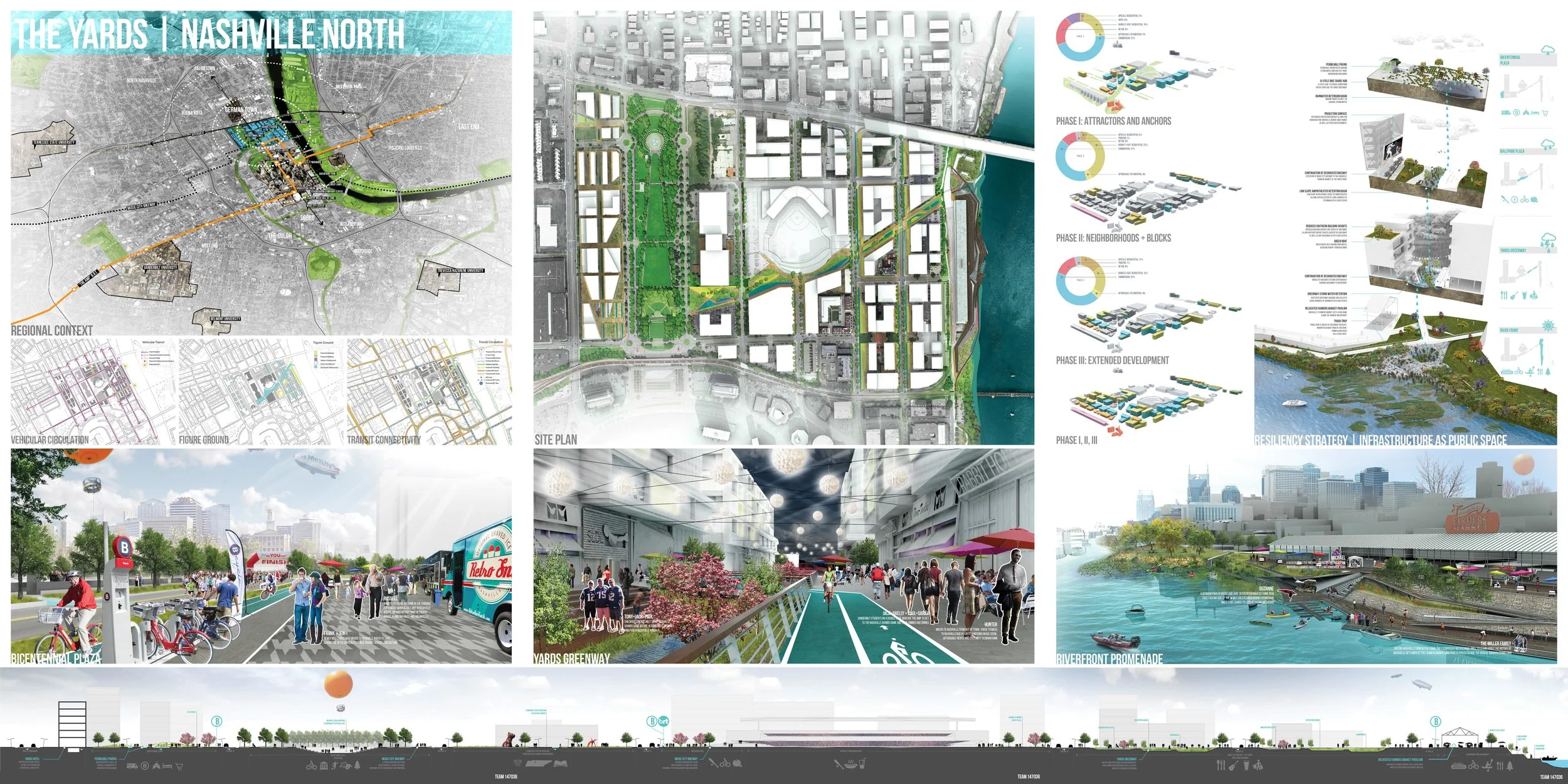
Nashville North Yards
Nashville’s relationship with water has proved to be an immense source of pride and joy, as well as an imminent risk. This project proposes a new urban paradigm which celebrates the energy of the Cumberland River as a dynamic platform for public life; this design seeks to pull the waterfront experience through a vibrant neighborhood formed upon this a mix of relationships and social spaces. Infrastructure designed as public space can begin to speak to a new type of community form, which has the potential to hold crowds as well as stormwater. Upon doing this, Nashville can celebrate its relationship with its natural environment in a way that is beneficial. By creating a mix of spaces able to function throughout the year, this plan seeks to be a new local destination which compliments downtown. Opportunities and amenities are important for attracting millennials as well as drawing in other visitors around the city.

Infrastructure Oriented Development
This urban design strategy uses stormwater infrastructure, which is necessary to protect the flood-prone district, as a development incentive. The green way typically serves as a corridor of mobility and access that supports the retail from the mall down to the market at the river-walk. During Storms the greenway doubles as a spine of retention and egress for storm water. The infrastructure corridor follows the historic creek at the districts low point. This creek once carried the natural runoff waters into the Cumberland River but was built over in the 1960’s. By daylighting this natural system the Nashville North Yards can use the revitalized infrastructure as a catalyst.

Finance + Infrastructure
• Our proposal has sited an elementary school or other institution in location A, as a way to interface adjacent neighborhoods as well as promote an increase in residents.
• At location B, the Nashville Farmer’s Market currently sits on highly valuable land. In the current market, it is more profitable to relocated the market to a more public location (4), and integrate another high activity program in its place.
• Location C serves as a new entrepreneur hub, in the form of an office neighborhood that makes use of the stadium’s activity and civic Infrastructure
• A LEED Certified hotel is proposed at location 1 to promote energy and stormwater management as a form of touristic development.
• The Linear Park at location 2 serves as stormwater infrastructure blended with public space. It functions as active space as well as rainwater capture, filtration, and retention in the event of various storm events; this ability has a value-capture component, increasing business value along it.
• Location 3 serves as adaptive reuse of the Sulfur Dell smokestacks; the area is relinquished for CSO management techniques and river level mitigation.
• The historic shed structure in location 4 has been retrofitted to house the Nashville Farmer’s Market in a waterfront location. This will promote activity along the river as well as reduce significant flood damage.

Site Plan
A Vision for North Downtown Nashville:
Attractors and Anchors
In the first stage of the proposal, Attractors and Anchors are used to set the stage for vibrancy along a highly capable landscape corridor. The momentum of the new ballpark stadium becomes an anchor by which development flows to along the Music City Bikeway. This bikeway, by use of City Bonds, becomes highly programmed to function as an attractor for all types of people – ranging from bicyclists, pedestrians, street musicians, to outdoor dining. By daylighting the creek beneath the bikeway, a new urban landscape can be realized.
Neighborhoods and Blocks
The second phase hinges off the re-imagined urban environment and seeks to create new neighborhood pockets that are a cross between downtown and suburban lifestyles. Its during this phase of development where mixed-use living and walkability are priorities for building a strong urban fabric as a whole.
Extended Development
Over the course of the development plan, the parcels to the west of the Bicentennial Mall are swapped with that of the riverfront properties releasing the land to the public realm, in accordance with Nashville’s vision of extended waterfront experience. The Nashville Farmer’s Market is given a more appropriate location on the riverfront and is located within a more flexible space.
Investing In Nashville
The success of this project is tied to the success of Nashville. Upon implementation, this project would seek to utilize local labor unions and groups as part of the construction process as well as building with local materials. This project seeks to not only bring businesses to invest in Nashville, but reside here in its neighborhoods as well.

Urban Detention Basin: Section A
The Western end of the site is at a higher elevation which is just outside of the floodplain. Grading was strategically done to create areas for stormwater detention. The hardscaped areas including the detention basins are paved with permeable pavers and have planters to encourage infiltration.

Bioswale at Stadium: Section B
In the district’s center a new baseball field will be built as part of the developments revitalization. At the edge of the stadium an amphitheater was designed to provide public seating and create a place for social gathering.

Stormwater Retention Basin at Commercial Corridor: Section C
In the center of the yard’s commercial corridor the bioswale is at its largest. This section of the swale accepts the majority of the districts runoff waters. During dry times the swale’s planting adorns the pedestrian street.

Stormwater Surge Buffer: Section D
The stormwater infrastructure begins and ends at the mouth of the Cumberland River. This section of the swale breaks the surging waters. The riprap here traps the trash and sediments for cleaning between tides.

Stormwater Infrastructure as Public Space
Several segments of the stormwater infrastructure work in concert to protect the adjacent urban areas from flooding. Waters filter through the native vegetation planted in the swales and detention basins, cleaning the waters before they are infiltrated into the ground or back through the system into the Cumberland River.

Riverfront Farmers’ Market
The historic Nashville Farmers Market is relocated at the end of the Yards walk to take advantage of the natural landscape. Also, moving the farmers market to this less valuable parcel opens up higher zoned land to create mixed-use developments.

The Yards: Bioswale/ Commercial Corridor
A view down the Yard walk shows how the pedestrian street’s relationship with the stormwater infrastructure and adjacent commercial spaces. The design creates an intertwined experience of function and access – making the process visible while enabling businesses and pedestrians to safely occupy the space.
Competition Boards
Team 147036

Minneapolis Crossing
The Minneapolis Crossing proposal intends to reactivate the east side of downtown Minneapolis in preparation for a stadium development. It is important to recognize that this is an opportunity to hinge reinvestment to activate the eastside of downtown by providing strategic park and open space systems. This given priority, will draw street activity from the stadium to the Central Business District (CBD). The design concept is based on connecting various hubs of activity: the river, university, stadium, CBD, and surrounding neighborhoods. This allows corridors of buildings to be reactivated through both the ground plane as well as an extension of the skyway system. Through the connection of two corridors, one leading from river to neighborhood, the other stadium to downtown, an open space system forms a knot through which pedestrian activity is given prominence. This strategy gives value to ground retail spaces as well as direct connections from the skyway to the ground plane. The placement of the main pedestrian plaza allows the historic Amory to become a focal point and through adaptive reuse, it becomes a cultural node serving as a market place.
The downtown cross district gathers the existing urban fabric via two urban corridors. Privileging pedestrians and bicyclists, the corridors catalyze activity. At their intersection, a new epicenter of commerce and public life is able to flourish. Expanding the Downtown West skywalk net-work into the new development extends an invaluable public infrastructure. Providing year round pedestrian access to the downtown buildings, the skyways are redeveloped to enhance the new development’s character and aesthetic. Providing and bridging green spaces, the new development creates a continuous public amenity through and across its site. The development is an area of respite for downtown inhabitants, linking public green space to open plazas and commercial life. Adapting and working with many of the historic properties, the new development not only respects the existing character of Downtown East but accentuates its qualities by creating nodes and connections around its most valued buildings. The plazas are intended to be reminiscent of the Minnesota landscape, which embody reminders of forest, meadow, and its placement within the city. The space is laid out in a way that allows for variety in its uses and program which allow for year-round flexibility. Paving patterns recall the Dakota Sioux tribe’s memory of the landscape through incorporating the weaving patterns and color into the ground plane.

Land Use
Movement and flow are important design strategies that tie together the spaces in the urban plan. The creation of corridors between zones charges the in-between space; it does so best when the corridor does not remain a thoroughfare but a branch in which to veer. In Minneapolis Crossing, two corridors are identified to connect the city, the passages entice movement through a series of public spaces and retail. The design uses the historic Amory building as the nexus of this connection, and through an adaptive reuse initiative, gives the area new life.

Competition Boards
The financing for this development occurs through 4 major phases, spaced three years apart. Ample growth occurs throughout phases 1, 2, and 3, with the 4th phase being a full build-out scenario. In the 1st phase, 2.2 million rentable square feet are to be built. The uses include, 10 floors of rentable housing, 3 floors of Single Room Occupancy, 2 floors of affordable housing, 14 floors of office space, and 10 floors of hotel. An additional $2.5 million is being allocated towards a plaza in order to create valuable open space that will pull in attention and investment. This first phase is intended to capitalize on the city’s need for office space as well as provide supporting elements such as hotel and connections to the skyway. This phase gains positive NPV after year 10, and continues to gain value until year 29, when the development maxes out value at 15%.
Phase Two hinges off the momentum from the first phase by allocating space for retail, in addition to continuing office and residential development. Ground level and skyway-level retail are integrated in the build-out scenario in order to further integrate new space with the current downtown. This phase does not gain a positive NPV until year 12, when it maxes out at a 13% IRR rate. Affordable units are included in this phase as well, in order to integrate both market-rate and affordable-rate uses early on in the project.
Phase Three allocates more space for office, as well as structured parking, and the largest plaza / park spaces in preparation for the activation of the new stadium. The stadium will increase activity sporadically throughout the year, however, in order to sustain the investments, other areas of activity must be emphasized. This phase allocates for the full build-out of park and open space systems that will ensure activity and attention to retail and businesses situated in the corridors extending from the stadium to the downtown. This phase also gains a positive NPV value after year 12, and continues to generate value until year 29.
The final phase, anticipates a full build-out of mixed-use residential development with ground floor retail in the peripheral areas. 31 floors are al-located to rental housing, while office space oriented towards the medical complex is also developed. The NPV becomes positive in year 14, and maxes out to an IRR of 12%.
Through these four phases, investment is centered on transit-oriented nodes as well as open space systems, in an inclusive strategy that anchors public investment. Value can be gained from city blocks that were once parking lots in a model that gives emphasis on business, lifestyle, activity, and events. The strategy is intended to be modest, but momentum-gaining as developments pick-up value in a long term vision. This project intends to tie into the existing and extensive investments the city has already made, and to capitalize on them to attract investment from local businesses and firms.
Re-Ball
Bronx Aquatic Museum- Aqua Cave
2014 URBAN LANDSCAPE INSTITUTE (ULI)
This project was a response to the disinvestment and stormwater challenges that the district has faced since the Great Depression. Contemporary market demands have pressured the city to evaluate the Sulphur Dell district for investment and enfranchisement. Located well within the 100 year floodplain – how can the Sulphur Dell district respond to the water threat and encourage development?
2013 URBAN LANDSCAPE INSTITUTE (ULI)
The property owners of 17 blocks of downtown Minneapolis, Minnesota entered an agreement in which they are evaluating their parcels for redevelopment. For the purposes of the competition our team acted as master developers for the combined 17.68 acres of prime real estate. The goal was to transform the district into a branded neighborhood and regional destination which incorporated the historic, social, environmental, demographic, environmental and economic identity of the city. In the submission the team developed a market-feasible development program and financial pro forma for the sites ten-year development.